Hiking Mission Peak, Fremont, CA

Hiking trails of Mission Peak, Fremont, California
Rising steeply to 2,497 feet (761.09 meters) above sea level behind the city of Fremont, California, is the Mission Peak Regional Preserve, offering 2,999 acres of landscape and hiking trails. Mission Peak is a popular destination for determined hikers and a launchpad for hangliders and paragliders. Sharing the airspace are hawks and vultures riding the thermals. Meadowlarks hobnob with the wildflowers, lupine and California poppies. And dotting the gentle folds of the hills are black Angus cows which can be seen at every elevation all the way near the summit.
There are several trails that converge to the Mission Peak summit with different levels of difficulty. Whichever one chooses, one thing is for sure. The three-mile trek to the summit is rewarding and uplifting as Mission Peak is one of the East Bay's most dramatic summits offering some of the most spectacular views of the entire Bay Area.
Take a two-hour hike in 3 minutes.
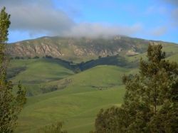
Mission Peak in April

Tufts of clouds hide the summit of Mission Peak. In the Spring, the rolling hills are green and the temperature just right for hiking. In the Summer, the hills turn brown and the heat can become unbearable. Snowcaps can be seen in the winter but are usually short-lived.This is the vantage point from just outside my backyard.

Getting up there
The easy way or the hard way
Mission Peak is served by three trails from its western face. The Peak Trail from Ohlone College has a gentler ascent to the summit but still requires endurance and proper pacing for the 3-mile uphill hike to a 2100 feet elevation change. The other two trails, the Hidden Valley Trail and Park Meadow Trail, which start at the Stanford Avenue off Mission Boulevard are shorter hikes, but strenous and steep all the way. One can take the three-mile hike straight out-and- back route the way you came, a part loop using the Park Meadow Trail or the 6 mile loop on the more demanding Horse Heaven Trail. All the trails offer very little shade and it is best to come prepared with motivation, lots of water, sunscreen, and a windbreaker. It gets gusty at the summit regardless of the season or time of the day.
One summer, I took the gentler route from Ohlone College with some friends and barely made it halfway to the summit, turned around and came back down. The one can of 7-Up in my backpack was not sufficient to quench my thirst in the summer heat; the pair of sneakers I wore did not have the traction and ankle support.
Photo Credit:Images by John 'K'
Sprawling residential homes in Fremont can be seen at the background as the trails begin to make the gradual ascent.
The hiking trails snake along the hillsides with the cows grazing undisturbed in the background. These black angus cows are known to be aggressive and territorial as they know the Mission Peak Regional Preserve is their turf. There are cows in every elevation and it is best to give them right of way along the trails as some are known to become feisty when approached.
Every so often, the verdant scenery tempts hikers and photographers to stop and soak in the beauty of Mother Nature. It is clearly impossible to turn your back on this incredible landscape.
Photo Credit: Images by John 'K'
The red-tailed hawk with its magestic wingspan is often seen gliding and riding the thermals.
This is one of the four benches along the trails with a view to boot. What a better way to catch one's breath, rest one's derriere and tired legs, take a sip of water, meditate and enjoy the view of the valley.
Every so often, you may come upon a shady grove of trees to cool off and catch a passing breeze. Harmless lizards may come and keep you company amongst the rocks. The more threatening rattlesnakes has been spotted now and then along the trails.
A lone leafless tree stands tall and proud along the trail next to the barbed wire fence to keep the cows at bay.
Two miles into the hike, you may stumble upon this odd-looking rock.These three holes carved in the rock were created by the Ohlone people and used as mortars to crush acorns, a staple of their diet.
Photo Credit:Images by John 'K'
Mission Peak Trail markers help hikers stay on the chosen paths whether it is the strenous 6-mile loop Horse Heaven Trail or the 3 mile back-and-forth Hidden Valley trail.
Stopping along the trail to take in the view

This is the view of the Ohlone Wilderness Trail as it approaches the summit of Mission Peak.
Flora and Fauna along the hiking trails
The Mission Peak Regional Preserve landscape has splashes of wildflowers, California poppies, lupine, and thistles on its nature's palette. The bees and wind pollination did most of the work since it is usually gusty near the summit area.
Photo credit: Images by John 'K'
Western larks, horned larks are some of the birds found hobnobbing with the flowers along the trails. Birds of prey, like the red-tailed hawks and vultures rule the skies.
The final stretch
Half the fun is getting there.
The final stretch to the summit along Peak Trail is rocky and steep. At 2.78 miles with a 2100 feet elevation change, Mission Peak summit beckons these determined hikers.
You know you are almost at the top when the clouds come to meet you. The last 100 ft. stretch is the hardest on your two-heeled drive.
With the summit looming ahead and drifting clouds beneath your feet, you know you have arrived.
This is the view of proud hikers reveling at their accomplishment of reaching the top of the Mission Peak summit. The summit observation pole with mini telescopes allows for a better view of the valley at every angle.
The Conquest

This is the reward that awaits the determined hikers at the top of Mission Peak- a view of Fremont and the entire Bay Area, all the way to San Francisco. On a clear day, all the bridges are visible including the Golden Gate Bridge. One can also see views of Mt. Tamalpais to the north, Mt. Diablo and the Sierra Nevada to the northeast, Mt. Hamilton to the south, Santa Cruz Mountains to the west.
On a clear day, one can see forever.....
A scallop seashell embedded into one of the boulders near the summit is a tell-tale sign that Mission Peak used to be submerged in water thousands of years ago.
On the way back down
Picture perfect
As you turn around to take one last look before heading down, you will see Mission Peak on the left, and Mt. Diablo to your right.
There are a few park residences sparsely scattered throughout Mission Peak Regional Preserve. In this idyllic scene, the cows are quietly grazing on a meadow overlooking the South Bay and San Francisco area. This is what I call picture perfect.
Oh, what a feeling! Just to sit and linger for a few minutes more before heading down the trails. The spectacular view is just too hard to resist.
Photo Credit:Images by John 'K'
One of the delightful surprises on the way down may be a hang glider quietly swooping down overhead. The Wings of Rogallo has a launch site within Mission Peak Regional Preserve to conduct hang gliding and paragliding activities. Started in the mid 70's, the Wings of Rogallo hang gliding club originally served the interests of San Francisco hang gliding pilots. It has now grown to one of the largest in the country with a roster of 500-600 hang gliding and paragliding pilots.
Photo Credit: Images by John 'K'
Sunset at the Mission Peak Regional Preserve is second to none. This awesome sight makes the hard climb to the summit well worth it.
This bench which served many passing hikers for the day, now sits empty, bathed in the glow of the setting sun waiting for another day.
Take this amazing 6-mile loop hike.
Mission Peak Loop Hike, Fremont, California at EveryTrail
This time lapse photography gives the uninitiated an idea of what it feels to be up at the summit of Mission Peak. The challenging stretch to the top is no match for these determined hikers.
Take this quick poll.
Have you ever gone trail hiking?
Interesting hiking links
- Hiking in Bay Area - Best Hikes, Guides, and Trail Maps | EveryTrail
Find the best hikes in and near Bay Area including detailed trail maps, guides, trail descriptions, Points of Interest (POIs) and GPS tracks / GPX data. All Hiking in the Bay Area, California guides can be downloaded to your iPhone and Android phones - Bay Area Hiker: Mission Peak Regional Preserve
This 5.6 mile out and back hike is a steep trek from the edge of a residential neighborhood to the top of the mountain. Hosts a Bay Area Ridge Trail segment. Distance, category, and difficulty: - Bay Area Hiker: Donner Canyon, Mount Diablo State Park
If you've ever been hiking on Mount Diablo in the summer, you may found the mountain to be well-named. 5 mile partial loop up Donner Canyon, then past a series of waterfalls. There are a few steep sections of fire road, and many short steep stretch - Bay Area Hiker: Best Hikes
Hiking Recommendations Best overall, in any season North Bay: Angel Island State Park Mount Tamalpais State Park: Matt Davis-Steep Ravine Loop Point Reyes National Seashore: Palomarin to Alamere Falls Peninsula and South Bay: Castle Rock Stat
The Best Hiking Boots
Your hiking boots are your #1 hiking gear. These can make or break a good hike. Your choice of hiking boots depend your taste and pocketbook. However, going cheap is not necessarily the wise thing to do either.
The boots that are showcased here are the top-of-the-line hiking gears. Asolo is Italian-made and are the Ferraris of the hiking boots - well-made for high performance and of course, on the expensive side.

Take a quick poll.
What do you like about Mission Peak hiking trails?
Cushion your feet
Similar to proper hiking clothes, cotton socks do not fare well during a hike. Choose comfortable socks that wicks moisture from the skin, are lightweight and dry quickly.

Save your knees and joints.
Hiking poles add stability when coming uphill and reduce shock on your knees when coming downhill. Poles with shock-absorbing tips help distribute the shock and weight to the rest of the body during the descent instead of concentrating them on your knees.
Leki Trail Trekking Pole
Wear the right clothes
Natural fibers like cotton do not do well in cold, ice, and water and do not wick sweat away from your body. It is recommended to used synthetic fabric that wicks moisture from your skin, that is also lightweight and dries quickly.
Wicked Lite Double Short Sleeve Tee
Men's Redwood/Red MD by Mountain Hardwear
Double Wicked Lite Short Sleeve T-Shirt
Women's Oasis Blue MD by Mountain Hardware
The backpack is your trusted friend
Choose the backpack that carry your essentials wisely. Whether it is for the casual day trek, the overnighter, or the strenous summit hikes, pick the right backpack accordingly. It could save your life.
Maxpedition .. Sitka .. Black


